Blog
Continental Drift: Comic Style
Based on the Continental Drift Lesson Plan, by Laura Balliett
Intro Activity
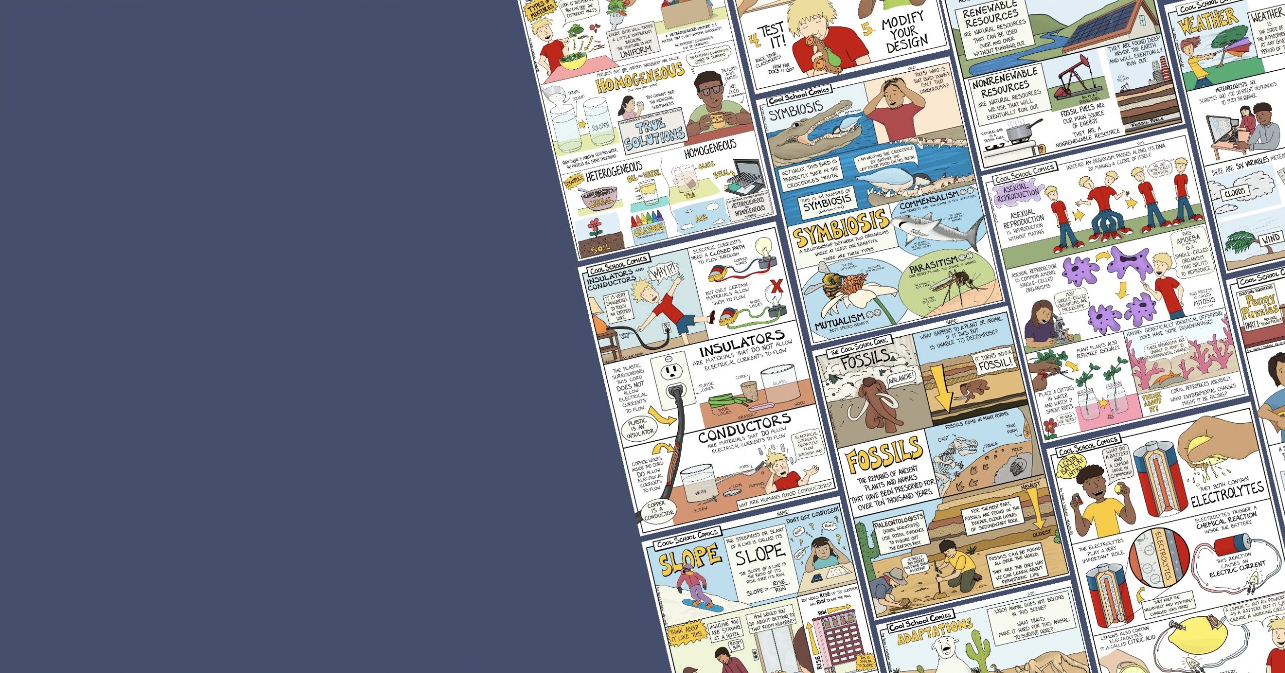
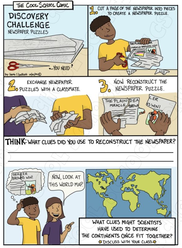
Every year, the continental drift lesson begins with an engaging group activity. With minimal explanation, newspapers and scissors are distributed throughout the class. I always left it up to the students to decide if they wanted to work alone or with peers.
Students were tasked with creating newspaper puzzles. They would simply cut the newspaper into several pieces and place them in a pile or envelope to be exchanged with classmates.
Some students created large-piece puzzles similar to the ones pictured in the image. Others created very tiny-pieced puzzles. Whatever the case, all of the students had to use the same clues to put the puzzles back together- shape and the connection of images or words.
Objective
The objective of this activity is to lead the students toward reflecting on the usage of these clues. While they did not have an original picture to reference, they had to implement alternative reasoning skills to complete the task.
This is similar to how Alfred Wegener developed his theory of continental drift. He did not have big satellite images of the continents, nor did he have seismic wave data. He had to use the clues he had on-hand to reach his conclusions.
Wrapping it Up
Throughout the lesson, I refer back to this activity to help keep the students in this mindset and solidify one of the key components of the lesson. The NGSS standards emphasize the importance of understanding the evidence of continental drift. The shapes of the continents and the fossil records found on each continent are a part of the evidence.
Once the students have completed the activity, I always bring them back together and discuss their experiences. I refer back to the comic as we hold the class discussion. Typically, I have the students glue the comic into their interactive notebooks and have them write any answers and/or notes there.
Continental Drift Content
Following the continental drift intro activity, I start covering the actual content. To accomplish this, I utilize the animated continental drift slideshow and the content comics. I do not hand out the full science comic until after I have gone through the slideshow. This way, students cannot drift ahead.
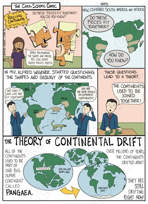
The main idea of continental drift is that the continents have moved and continue to move over time due to movements in the Earth’s crust. This theory was first proposed by Alfred Wegener in 1912, but it was not widely accepted until the 1950s when the theory of plate tectonics was developed, which provided a mechanism for continental drift. The concept of continental drift is now widely accepted in the scientific community as a key part of plate tectonics.
The Four Main Clues to Continental Drift:
- Fit of the continents: The coastlines of Africa and South America fit together like puzzle pieces, suggesting that they were once part of a larger landmass.
- Similar fossils and rock formations: Similar fossils and rock formations are found on opposite sides of the Atlantic Ocean, suggesting that the continents were once connected.
- Climate evidence: Fossils of tropical plants and animals have been found in Antarctica, suggesting that the climate was once warmer and that the continent has since moved to a colder location.
- Paleomagnetism: The study of the Earth’s ancient magnetic field has shown that the continents have moved over time, and that the locations of the magnetic poles have changed.
To develop this comic, I referred to the textbooks I had on hand and utilized PBS Learning Media.
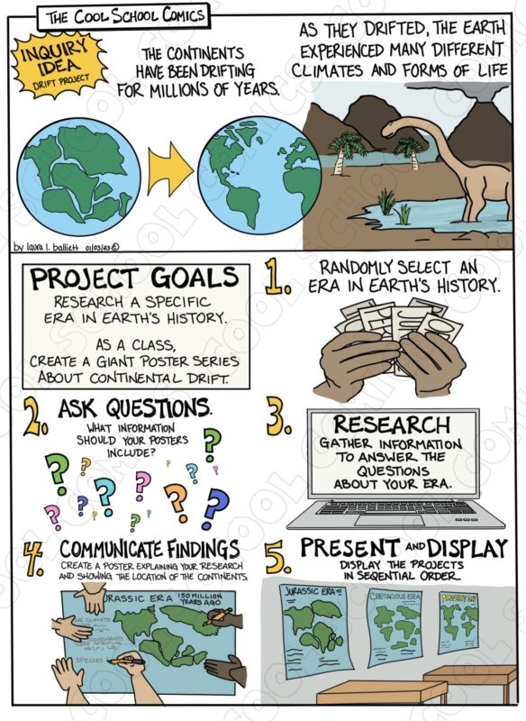
Final Project
When I began teaching this topic, I was teaching at a charter school for at-risk youth. Not only was it challenging to get my reluctant readers to read the content, but regulating behavior was another struggle. Big hands-on projects involving supplies were out of the question. So, I had to lean heavily on incorporating art with science.
For this project, I used giant sheets of blue and green paper from the giant paper rolls located in the art room. The vision was to create a large-scale poster series of the continents drifting and hang the poster is the hallway for everyone to see.
Just like the comic models, students selected the era they were going to research at random. I supplied every group with a rubric to keep them on-task toward the goal. In the lesson plan, I give teachers the option of using my rubric or creating their own.
To create the giant continents, I projected the image on the board. Students would tape their green paper to the board as well and trace the image being projected onto the paper. This allowed students to get accurate continent locations and sizes.
Students followed the steps in the comic as I circulated the room answering questions and giving tips. This project would take my students almost a week to complete.
Other Project Ideas
- Model building: Create a model of the Earth’s crust using different materials (such as clay or play dough) to represent the different types of rock. Show how the plates move and interact with each other using your model.
- Fossil research: Research and present on a specific fossil that is found on multiple continents, such as the Glossopteris plant. Explain how the fossil provides evidence for continental drift.
- Plate tectonics simulation: Create a simulation using materials such as plastic plates and marbles to demonstrate how plate tectonics causes the movement of the continents.
- Climate change research: Research and present on how the movement of continents affects climate change. Explain how changes in continental drift have led to changes in climate and how this is supported by fossils and rock formations.
- Geography challenge: Create a map of the world as it is today and then another map of the world as it would have been millions of years ago, based on the evidence of continental drift. Challenge your classmates to identify the differences and similarities between the two maps.
The YouTube Short
As a new addition to the Cool School Comic repertoire, I have begun creating YouTube shorts and videos. At the moment, there are only a few, but I love making them. There will certainly be more.
This short clip discusses Iceland, one of the best places on Earth to observe continental drift.
Iceland is located a divergent plate boundary where two tectonic plates are moving away from each other. This boundary is called the Mid-Atlantic Ridge. The Mid-Atlantic Ridge is a volcanic zone where magma from the Earth’s mantle rises up to fill the gap created by the separating plates. This volcanic activity is the reason for Iceland’s high volcanic activity and geothermal activity.
Iceland is situated on the North American plate and the Eurasian plate. The North American plate is moving to the west and the Eurasian plate is moving to the east. As a result, Iceland is being pulled apart in a process called rifting. This is causing the island to gradually increase in size as new land is formed by volcanic activity.
The movement of the tectonic plates also causes earthquakes in Iceland. These earthquakes are caused by the stress that builds up as the plates are pulled apart. Iceland is also known for its hot springs, geysers, and fumaroles. These are caused by the volcanic activity and geothermal heat associated with the divergent plate boundary.
Continental Drift and Plate Tectonics
This lesson plan serves as an introduction to continental drift. It can serve as a segue to a plate tectonics unit.
Plate tectonics is the scientific theory that explains how the Earth’s lithosphere (crust and uppermost part of the mantle) is broken into a number of rigid plates. These plates move around on the softer, more fluid asthenosphere (the upper part of the mantle). The movement of these plates is driven by convection currents in the Earth’s mantle.
The lithosphere is broken into several large plates, including the North American, South American, African, Antarctic, Eurasian, and Australian plates, and several smaller ones. These plates move around on the Earth’s surface, colliding, sliding past each other, and spreading apart. When two plates collide, one may be forced underneath the other in a process called subduction. While when two plates move away from each other, new crust is generated by the upwelling of magma.
The movement of the plates is slow, usually only a few centimeters per year. Over millions of years, this movement can cause significant changes to the Earth’s surface, such as the formation of mountains and the creation of a new oceanic crust.
Continental drift is caused by the movement of tectonic plates driven by the convection currents in the Earth’s mantle. To learn more about convection currents, check out the complete Convection Currents Lesson Plan.